
GONDWANA
The conventional plate tectonic supercontinental assemblage of Gondwana is made up of an assemblage of the present-

The Ordovician Gondwana Expansion Tectonic small Earth assemblage. This model shows the ancient coastline distribution (blue lines) defining North and South Gondwana in relation to Laurentia, Baltica, and Laurussia. The ancient Tethys, Iapetus, and Panthalassa Seas form part of a global network of continental seas (shaded areas) surrounding each of the exposed supercontinents.
From its initial assemblage, the conventional Gondwana assemblage is then said to have remained intact throughout the Palaeozoic to Early Mesozoic times. As a number of researchers have noted though:
...past movements of the Gondwana supercontinent, based on ancient magnetic, biogeographic and climatic evidence, are both equivocal and contentious, and this contention still remains despite the addition of new data from Africa and Australia.
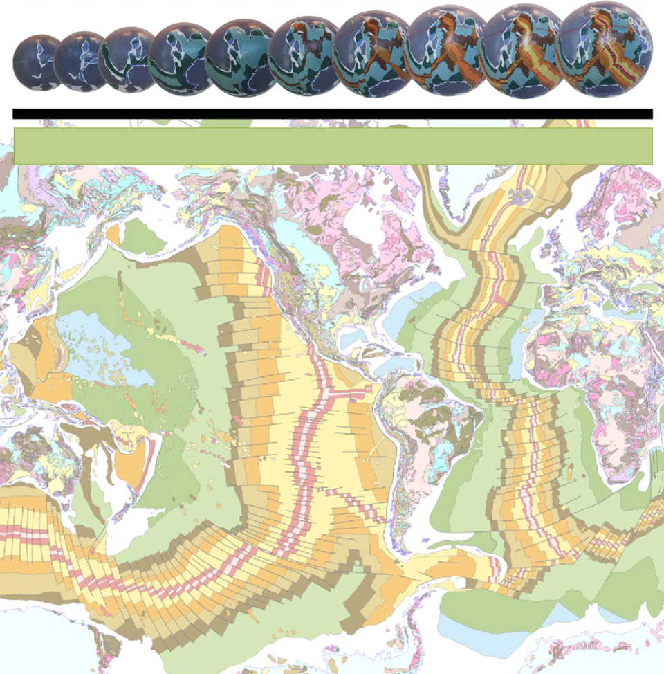
Gondwana on an Expansion Tectonic Earth is shown reconstructed on the Ordovician small Earth model above. The published ancient coastal outlines are also shown as blue lines and the continental seas as shaded blue areas. These coastal outlines, which simply represent the global distribution of the ancient beaches existing at that time, were plotted from published geographical data. This distribution of ancient coastlines, in effect, defines the outlines and locations of the ancient supercontinents and lesser sub-
On Expansion Tectonic small Earth models, prior to the early-
On the Ordovician Expansion Tectonic small Earth model the Gondwana supercontinental assemblage is the outcome of an evolving change in coastal outlines and sea-
During this Gondwanan time the Earth surface underwent a steady to rapid increase in area and was fast approaching crustal rupture—the moment in time when the continental crusts first began to fail and breakup. This Gondwana crustal assemblage retained the exact same configuration of cratons, orogens, and basins as seen in both the Rodinia and primordial Archaean supercontinents. The only difference being the greater surface area of surrounding sedimentary basins and hence aerial distribution of continental seas. This crustal assemblage is retained still further until initiation of crustal rupture and breakup of the pan-
The coastal information shown on the Ordovician small Earth model shows that, at that time there were distinct elevated ancient land surfaces. These land surfaces were in turn surrounded by a network of equally distinct, relatively shallow continental seas. Gondwana on this model was subdivided into a North and South Gondwana, separated in part by an early Panthalassa Sea—the precursor to the modern Pacific Ocean. North Gondwana was made up of Australia, East and West Antarctica, and India and also possibly included Tibet and Afghanistan. South Gondwana, joined at Madagascar, comprised Africa, Arabia, and South America. The ancient sub-
Each of these exposed Gondwanan land surfaces were in turn surrounded and interconnected by the ancient continental Tethys, Iapetus, and Panthalassa Seas. Remnants of these seas are now preserved and represented by many of the ancient sedimentary basins that are located in Eastern Australia, North and South America, Europe, Asia, and Africa.
This Expansion Tectonic small Earth Gondwana assemblage, however, differs markedly from plate tectonic reconstructions.
On an Expansion Tectonic Earth Eastern Australia, for instance, is assembled adjacent to both North America and South America and is separated by a narrow Panthalassa Sea, as distinct from the need for a very much wider conventional Panthalassa Ocean.
The existing physical and geological similarities between the Australian and South American continents have long been acknowledged in a number of publications. These similarities include the distribution of marine and terrestrial plants and animals, which link Australia with New Zealand across to Central and Southern America, and also rock and fossil types that link Australia directly with South America. It should be appreciated that these physical links between each of these modern continents can only be maintained on an Earth that had a much-
In contrast, because of the plate tectonic requirement for a very large ancient Panthalassa Ocean, conventional reconstructions generate enormous separations which cannot be justified or reconciled with the factual geological or geographical evidence.
The interval of time that Gondwana existed on an Expansion Tectonic Earth is characterised by a rapidly accelerating phase of increasing surface area and accompanying changes in surface curvature. These accelerating changes gave rise to a marked increase in erosion and deposition of sediments and marked changes to the distribution of continental seas and coastal outlines. The increasing changes in surface curvature also initiated localised compression of the sedimentary basins to form long linear fold mountain belts, further disrupting established seaways.
It is significant to note that these times also coincided with the rapid development and evolution of all life forms on Earth. Evolution of species is often seen as driven by the need to keep pace with environmental change and similarly extinction is seen as a by-
During Gondwanan times, the Expansion Tectonic Earth South Pole was located within central West Africa in what was then South Gondwana. The North Pole was located within Northern China in what was part of the Tethys Sea. The ancient equator passed through East Antarctica, central Australia, North America, central Eurasia, and India, through what was then North Gondwana. This geographic configuration approximates plate tectonic reconstructions in part, but differs substantially in the South Pacific region because plate tectonics requires the presence of a wide expanse of Panthalassa Ocean.
The distribution of Expansion Tectonic coastal outlines and seas also show that continental land connections existed between north Australia and North America and between north Africa-
The late-
On an Expansion Tectonic Earth this evolution of continents and seaways is reflected in the progressive changes to coastal outlines and sea levels, as faithfully displayed in each of the small Earth models.