
FREE STUFF
More Free Stuff is is being developed. Send me a contact message and tell me what else you would like and I shall do the best I can.

 BEYOND PLATE TECTONICS (2nd Ed.)
Bringing it altogether in this extensive 459-page book on Expansion Tectonics explaining the scientific evidence behind the concept in detail.
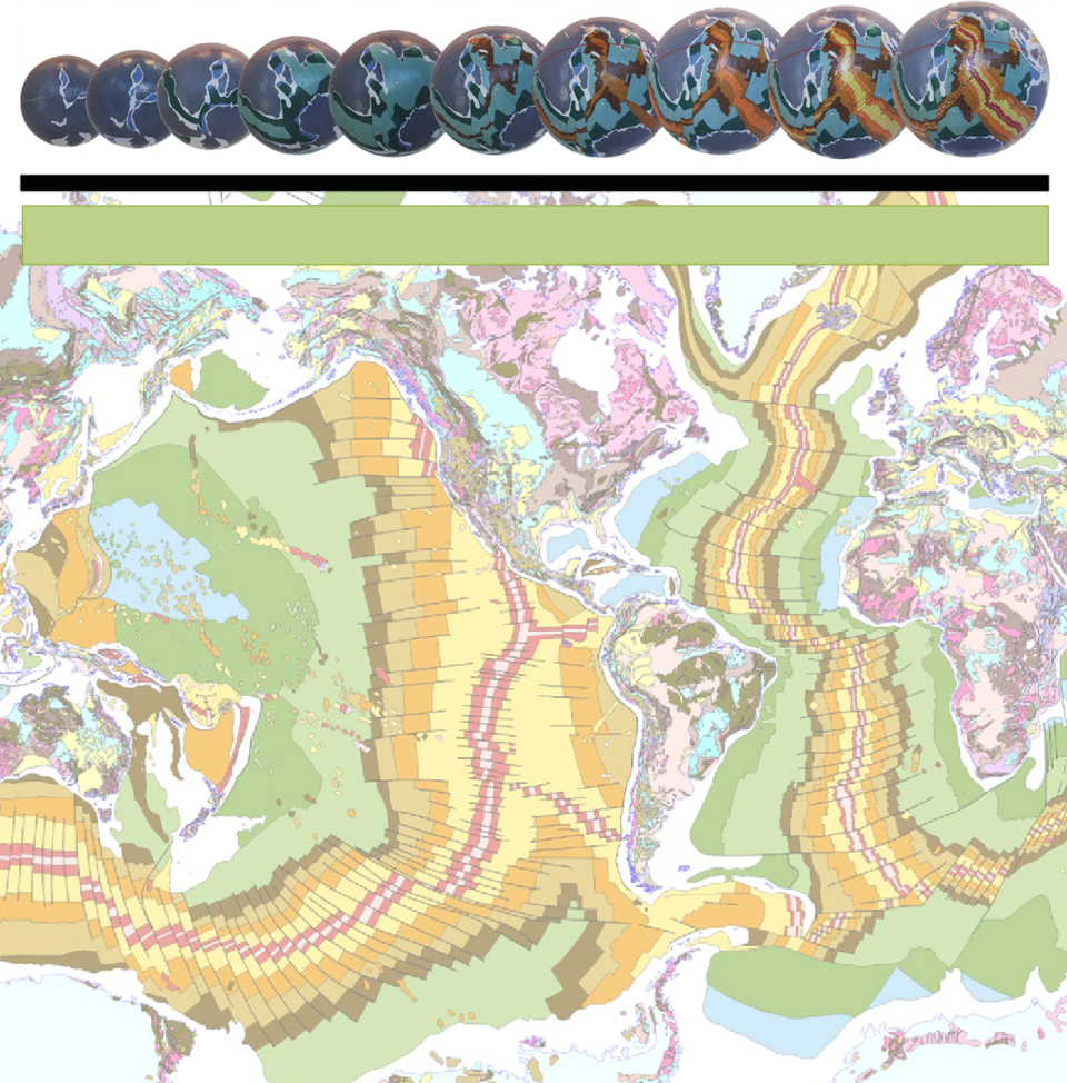
EXTENSIVE PAPER ON EXPANSION TECTONICS Learn about the scientific evidence in this free extensive 114-page introductory paper on Expansion Tectonics outlining the entire concept in detail. (Click here to access this download) SINUSOIDAL MAP - Click on link below to display a large format PDF Geological Map of the World map in 24- MAXLOW ANIMATED GLOBE VIDEOS The links below will take you to a selection of geography and geology videos showing animated globes for the various times shown. These globes were constructed back in time by successively taking away the coloured seafloor stripes and reassembling the remaining plates on smaller radius globes. Similarly, the continents were reconstructed back in time by progressively removing young sediments from the established network of sedimentary basins and returning the basins to a pre- Seafloor Geology video This video moves back in time from the Present-day to the Triassic Period, some 200 million years ago. Each small Earth model will rotate once before removing the next oldest seafloor crustal stripe in turn and refitting the remaining plates back together on a smaller radius Earth model. The video demonstrates conclusively that the plate fit-together for each successive model has a better than 99% fit without the need to impose arbitrary crustal break-up, inferred pre-existing crusts, or to remove crusts by subduction. Supercontinental Geology video This video starts during the late-Permian Period, some 250 million years ago, and moves back in time to the beginning of the Archaean Eon, some 4,000 million years ago. Each small Earth model will again rotate once before partly removing sediments from a global network of sedimentary basins, plus intruded or extruded magmatic rocks, and refitting the remaining continental crustal plates on a smaller radius Earth model. By sequentially removing sediments and magmatic rocks and returning them to their places of origin, a primordial Archaean Earth model is achieved comprising an assemblage of the most ancient crustal rocks existing on Earth today.
Cenozoic Geography video In this video we start at the beginning of the Paleocene Epoch, some 66 million years ago—at the end-Cretaceous or K-T extinction event—and move forward in time to the present-day. Shown is the continental and seafloor geology, as shown in the Geological Map of the World, plus ancient coastal outlines as blue lines. These outlines define the distribution of ancient seas on each model.
Mesozoic Geography video This video starts at the beginning of the Triassic Period, some 145 million years ago—at the end-Triassic extinction event—and moves forward in time to the end of the Cretaceous Period, some 66 million years ago. Shown is the continental and seafloor geology, as shown in the Geological Map of the World, plus ancient coastal outlines as blue lines. These outlines define the distribution of ancient seas.
Permian Pangaea video This video shows the assemblage of all modern continents to form the ancient Pangaea supercontinent just prior to breakup some 250 million years ago. Shown is the continental and seafloor geology, as shown in the Geological Map of the World, plus ancient coastal outlines as blue lines. These outlines define the distribution of ancient seas prior to opening and draining to form the modern oceans.
Phanerozoic Geography video This video starts at the beginning of the Cambrian Period, some 541 million years ago, and moves forward in time to the Present-day. Shown is the continental and seafloor geology, as shown in the Geological Map of the World, plus ancient coastal outlines as blue lines. These outlines define the distribution of ancient continental seas prior to breakup of the ancient Pangaean supercontinent at the end of the Permian Period, some 250 million years ago, to form the modern continents plus opening to form the modern oceans.
All Geology video This video starts at the beginning of recorded geological time, at the beginning of the Archaean some 4,000 million years ago, and moves through the entire geological history of the Earth to the Present-day, plus extends to 5 million years into the future. By moving forward in time each of the continental sedimentary basins progressively increase in surface area during increase in Earth radius. The ability for the continental sedimentary basins to continue stretching is then exceeded during the Permian Period leading to crustal rupture during the end-Permian, some 250 million years ago. This then initiates breakup of the Pangaean supercontinent to form the modern continents plus opening to form the modern oceans.
GOOGLE EARTH DRAPES
The following links will take you into Google Earth where you will be able to see and rotate for yourself a selection of seafloor globes draped over Google Earth. When operating these drapes just be aware that Google Earth is just a platform for draping the various maps on. As such, only the present-
Click on the following links to launch Google Earth and display the various map drapes.
Present-
Miocene Google Earth map drape [23 Ma to 5.3 Ma]
Oligocene Google Earth map drape [33.9 Ma to 23 Ma]
YouTube VIDEOS
A comprehensive list of animated videos and lectures can be found on YouTube. These include:
 James Maxlow -
Yes! The Earth is Expanding.
[Click here to view video]
 James Maxlow -
Global Expansion Tectonics: A Significant Challenge for Physics.
 James Maxlow -
 James Maxlow -
The Expanding Earth. An interview with James Maxlow.
[Click here to listen to the interview]
 Stephen Hurrell -
Dinosaurs and the Expanding Earth. An interview with Stephen Hurrell.